Ancient Greek Natural Resources: GREECE, Fellas, officially known as the “Hellenic Republic” is the southeastern most country in Europe, occupying the southernmost part of the Balkan Peninsula. It is bordered by Albania, X-Yugoslavia (the Republic of Skopje) and Bulgaria from the north, and the European part of Turkey from the northeast.

From the east by the Aegean Sea, from the south by the Mediterranean Sea, and from the west the Ionian Sea, including more than 400 islands, which occupy more than one-fifth of its total land territory the total area of the country, is 131,957 square kilometers (50,949 square miles).
Ancient Greek Natural Resources
The mainland portion of Greece comprises the regions of Thraki and Macedonia in the north; Epirus, Thessaly, and Central Greece in the central section; and in the south Peloponnisos, a peninsula which is connected to the rest of the mainland by the Isthmus of Corinth. The remainder of Greece consists of more than 400 islands, (only 149 are inhabited.)

These are Evia, Crete, or Kriti, the Northern Sporades, the Cyclades, the Dodecanese, Chios, Limnos, Lesvos, Samos, Samothraki, and Thassos, all of which are spread out in the Aegean Sea. In the west, the Ionian Sea is where the Eptanisa is found, a group of seven inhabited major islands and three small uninhabited ones.
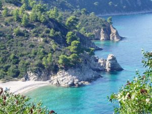
The coastal waters of the country are relatively shallow and penetrate far inland. Despite its indented coastline, Greece has fine natural harbors, namely its main harbor of Piraeus, the second largest in the Mediterranean Sea, after Marseilles in France. Piraeus is considered an excellent harbor in the East Mediterranean waters.
Land and Resources
Greece is famous for its natural beauty. The land is mountainous and rugged, but Greece is relatively poor in Ancient Greek Natural Resources. Although a small country, Greece has a very diverse topography.

The most important divisions of the country are the central mountains; the damp, mountainous regions in the west; the dry, sunny plains and lower mountain ranges in eastern Thessaly, Macedonia, and Thraki; Central Greece, the southeastern “point” (peninsula) of the mainland that cradled the city-states of the country, the mountainous regions of Peloponnesus; and the islands, most of which are in the Aegean Sea.
The central mountain area, the Pindus Mountains, which extends from a northern to a southern direction, is one of the most rugged, isolated, and sparsely populated parts of the country.
Mount Olympus (2,917m/9,570ft), Greece’s highest peak, was considered in ancient times to be home to the 12 gods. Its western slopes, which extend through Epirus down to the Ionian Sea, are lower and more hospitable.
The southeastern extremity of Central Greece, Attica, is broken into many isolated valleys and plains by mountain ridges, where the Athenian Plain, with Athens in the center, is located. Thessaly, a plain ringed by mountains, is one of the most fertile parts of the country.

Largest plains in Greece
Macedonia has the largest plains in Greece. Thraki, east of Macedonia, has a varied topography of mountains, valleys, and several coastal plains. Peloponnesus is mountainous, but to a lesser degree than Central Greece.
It is shaped like a giant hand with impassable mountain ridges extending like fingers into the sea. Between the mountains are narrow valleys, which are isolated from one another, but which open onto the water.
The western section of Peloponnesus is less mountainous than its eastern parts. The islands of the Aegean Sea are generally high, rugged, stony and dry, and consequently, their contribution to the economic life of the country is limited. They are important, however, because of their great beauty, historical importance, the potential for tourism and strategic military value.